Airborne Laser Scanning
1st project cycle (2017 – 2023) and creation of DTM 5.0
Since 2017, the Geodesy, Cartography and Cadastre Authority of the Slovak Republic (ÚGKK SR) was preparing (in a contractor manner) a new Digital Terrain Model (DTM 5.0) of the entire territory of the Slovak Republic created from Airborne laser scanning (ALS) data. In May 2023, the 1st cycle of the ALS project was completed by making the seamless DTM 5.0 of the entire territory of Slovakia available to the public.
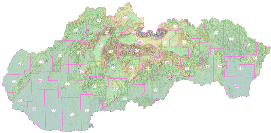
In the 1st cycle of the project, the territory of Slovakia was divided into 42 sites (lots). The scanning was carried out in the vegetation-free winter period gradually from the west to the east of Slovakia.
- Overview of lots in Shapefile format (1st ALS project cycle)
- Overview of parameters of available lots (1st ALS project cycle)
- Overview of LAS file footprints (1st ALS project cycle)
More information about the 1st ALS cycle can be found here.
Information about the provision of ALS products from the 1st cycle is here.
DTM 5.0 in the MAPKA application:
Point clouds in the MAPKA application in 3D view:
Tutorials to help you work with ALS Products can be found at the following links:
- How to work with DTM in QGIS application (Slovak only)
- How to work with point cloud in QGIS application (Slovak only)
- How to unpack LAZ format to LAS format using LASzip (Slovak only)
2nd project cycle (2022 – 2026) and creation of DTM 6.0
Since 2022, ÚGKK SR has been updating the ALS Products within the 2nd cycle of ALS data collection on selected parts of Slovakia, again in a contractor manner. Subsequently, the Digital Terrain Model (DTM 6.0) and the Digital Surface Model (DSM 2.0) will be processed from the delivered classified point cloud by ÚGKK SR. In principle, the entire 2nd cycle of the ALS project will be divided into 3 parts (4-year periods).
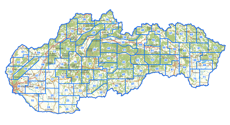
The whole territory of Slovakia is divided into 73 lots. The scanning of selected lots is again carried out in the vegetation-free winter period from the west of Slovakia to the east.
- Overview of parameters of available lots (2nd ALS project cycle)
- Overview of lots in Shapefile format (2nd ALS project cycle)
- Overview of LAS file footprints (2nd ALS project cycle)
More information about the 2nd ALS cycle can be found here.
Information about the provision of ALS products from the 2nd cycle is here.
Comparison of basic information and required parameters of 1st and 2nd cycle
|
|
1st ALS Cycle (DTM 5.0) |
2nd ALS Cycle (DTM 6.0) |
|
Cycle duration: |
5 years (1 FD) |
12 years (3 FA) |
|
Number of FA participants: |
5 |
4 |
|
Final ALS products: |
classified point clouds DTM DSM |
classified point clouds DTM DSM |
|
ALS lots (area): |
900 to 1800 km2 |
500 to 900 km2 |
|
Total number of lots: |
42 |
73 |
|
ALS period: |
vegetation free season (from 01.11. to 30.4.) |
vegetation free season (from 15.10. to 15.4.) |
|
Last reflection point density (lrp): |
min. 5 lrp/m2 |
min. 15 lrp/m2 |
|
Beam trace: |
max. 0,25 m |
max. 0,45 m |
|
Overlap of swaths: |
< 20% |
< 40% |
|
Transverse swaths: |
1 for each flight |
min. 3 per lot |
|
Classification of point clouds into classification classes: |
compulsory - 2 classification classes optional - 10 classification classes |
compulsory - 10 classification classes optional – Power lines (Wire) and Tower |
|
Verticalaccuracy of cloud points: |
mh ≤ 0,11 m |
mh ≤ 0,10 m |
|
Positional accuracy of cloud points: |
mXY ≤ 0,30 m |
mXY ≤ 0,20 m |


