1st project cycle (2017 – 2023) and creation of DTM 5.0
Basic specification of the project
The whole territory of the Slovak Republic was divided into 42 lots:

The ALS took place gradually by individual lots from the west of Slovakia to the east. The awarding of contracts for the ALS and the implementation of the works at the individual lots was carried out by successive re-opening of tenders between the 5 participants of the framework agreement, which were:
- EMIS spol. s r.o.,
- Eurosense spol. s r.o.,
- Photomap spol. s r.o.,
- Skupina dodávateľov PRIMIS spol. s r.o. a MILAN Geoservice GmbH,
- Flycom d.o.o.
The subject of the contract was:
- data collection by airborne laser scanning,
- processing of point clouds and delivery of classified point clouds*,
- delivery of DTM in raster form,
- delivery of DSM** in raster form,
- quality control of point clouds and DTM.
*Compulsory classification into 2 classes - 01 Unclassified, 02 Ground.
Optional classification into 10 classes - 01 Unclassified, 02 Ground, 03 Low vegetation, 04 Medium vegetation, 05 High vegetation, 06 Building, 07 Low point (Noise), 09 Water, 17 Bridge deck and 18 Hight Noise.
**Optional part of delivery
Note: Given that the successful tenderers' bids were evaluated on the basis of the most economically advantageous tender criterion, the suppliers had the possibility to offer qualitatively higher parameters than were the mandatory criteria. For this reason, the resulting products vary slightly from lot to lot.
Compulsory quality criteria:
- scanning density: min. 5 points per m2,
- overlap between swaths min. 20% on 95% of their mutual coincidence,
- horizontal and vertical system: S-JTSK(JTSK03)+HBpv; ETRS89-TM34+hETRS89,
- abs. vertical accuracy of point clouds at ellipsoidal heights ETRS89 - mh ≤ 0,15 m,
- abs. positional accuracy of point clouds in ETRS89-TM34 - mXY ≤ 0,30 m,
- abs. vertical accuracy of DTM 5.0 in hETRS89 - mH ≤ 0,20 m,
- abs. vertical accuracy of DTM 5.0 in Bpv - mH ≤ 0,25 m.
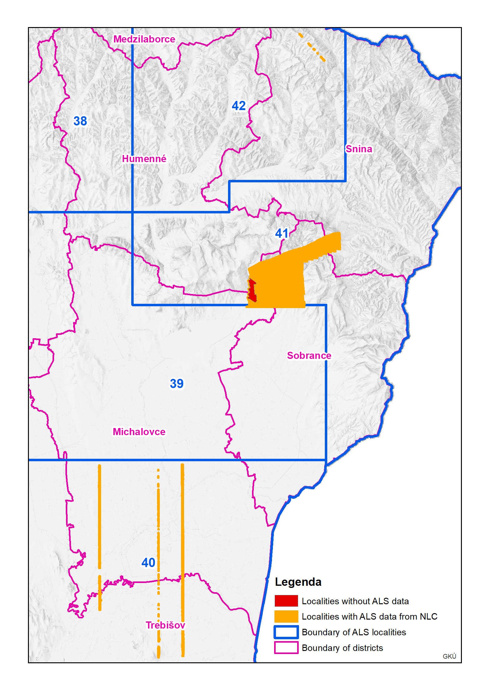
ALS was carried out at individual lots mainly during the vegetation-free winter period from November to April. The only exceptions were 4 high mountain areas (LOT 17, 19, 24, 26) where ALS was carried out in the summer growing season from May to September. Lots no. 37, 38, 40, 41 and 42 in eastern Slovakia were scanned during the special period of the beginning of the war in Ukraine, and due to security measures some parts were being scanned until 30 June 2022. In lots no. 40, 41 a 42 some areas could not be scanned and the data there were therefore supplemented from ALS by the National Forest Center (NLC) from 2018 to 2023, an overview of these sites is available here.
The result of laser scanning is so-called "point cloud" that correspond to the Earth's surface from which the laser pulse is reflected. 
Digital Terrain Model DTM 5.0 was created by interpolation from the Classified point clouds. Class 02 Ground was used as the input classification class. The output was a raster in ASC, ESRI GRID or TIFF format in 1 x 1 m resolution.

Digital Surface Model DSM 1.0 was created by interpolation from the Classified point clouds (from selected classification classes). The input classification classes were 01 Unclassified, 02 Ground, 03 Low vegetation, 04 Medium vegetation, 05 High vegetation, 06 Building, 17 Bridge deck and 09 Water, from which only the first reflection points were used. The output was a raster in ASC, ESRI GRID or TIFF format in 1 x 1 m resolution.

Quality control:
The quality control was carried out independently by the contractor and ÚGKK SR. The contractor demonstrated by the results of its own control that all the specified conditions and quality parameters were met. ÚGKK SR, in cooperation with GKÚ Bratislava and VÚGK, carried out the control to independently verify the fulfilment of contractual requirements. Only on the basis of the successful results of both controls did ÚGKK SR accept the work.
The subject of the controls was mainly:
- scanning density (last reflection points),
- overlaps of adjacent swaths,
- relative vertical and horizontal accuracy,
- correctness of point classification into defined classes***,
- absolute horizontal and vertical accuracy of point clouds,
- absolute vertical accuracy of DTM.
***In the Ground class, a maximum of 0,5% occurrence of misclassified points per 1 km2 of territory was allowed. In other classes (except Unclassified) a maximum of 10% of misclassified points per 1 km2 of territory was allowed.
An absolute horizontal and vertical accuracy control of point clouds and control of the absolute vertical accuracy of the final DTM was carried out at geodetically surveyed vertical and horizontal control points (using SKPOS), located on open paved areas at several randomly selected locations within each lot.
Further specifications and actual quality parameter values achieved by the contractors for individual lots are given in the metadata of the respective dataset and in the table HERE.
Explanation of terms:
Terrain is a natural or man-made land surface without static and dynamic landscape features such as vegetation, buildings, bridges, vehicles, people, etc.
Digital Terrain Model (DTM) is a raster or spatial surface in digital form representing terrain. It is created from elevation data and an interpolation algorithm, whereby there is only one elevation value for any point position.
Notes:
- The DTM beneath structures taller than 0,30 m was interpolated from the surrounding terrain.
- For water bodies and streams, the DTM represents the current (at the time of scanning) water level interpolated from points on the bank less than 1 m from the shoreline or points on the water surface.
The DTM includes:
- embankments (e.g., rail, road, dike, etc.) and retaining walls,
- surface quarries, excavations, and cuttings,
- naturally accumulated natural material such as rocks, debris, leaves, snow fields in high mountain environments in summer, etc.
The DTM does not include:
- vegetation higher than 0,30 m,
- building and other objects higher than 0,30 m above the surrounding terrain,
- underground objects,
- parts of the bridge that are separated from the terrain by open space, including other structural parts of the bridge.
Digital Surface Model (DSM) is a digital elevation model that represents the relief/terrain including the top surfaces of all objects located on it (building roofs, vegetation, water bodies, etc.).
Information about the provision of ALS products from the 1st cycle is here.
Updated: 19.07.2024